Saturday, May 7, 2016

5/07 Onancock, VA and the Kentucky Derby

Let me tell you, it is so wonderful that so many people are following our voyage here.  Some are putting pins in maps to follow our journey.  We enjoy hearing from all of you.  Here is Sarah reading the blog this morning.  Hi, Sarah.
Finally, today we saw the sunshine!!!  So we headed across the Chesapeake to the tiny town of Onancock, VA.  It is a small artist colony now, but was founded in the 1600's.
Captain John in the Sunlight on the Fly bridge
We strolled from the wharf to downtown.  So many beautiful colonial homes.  This one was outlined by a bridge near our slip at the town marina.
The town had a memorial park with the obelisk to General Bagwell who died in 1876 and founded the Masons in Onancock, and a marker that remembered those who served in World War I and World War II.  Another commemorated Francis Makemie, who in October 5, 1699, was the first licensed preacher in Onancock.
 

What a fun town this is though!!!  We went to the Blarney Stone Pub.  They were having a Kentucky Derby party and we joined right in.  Everyone drew the name of a horse to cheer on.  They had a Derby Hat Contest with very inventive contestants.  The two ladies below tied for first.  But you have to give the fellow an A for effort.
Neither John nor I had the winner of the derby.  John's horse might still be running to cross the finish line.  But we had a blast and the food and friendship was terrific.
Sunset from the Bow of The Hydrophilic AAHHH
Lat 37 degrees 42.69 North
Long 75 degrees 45.30 West

Friday, May 6, 2016

5/06 to Deltaville

Wolf Trap Lighthouse

So last night we had another first.  We settled in at the dock safe and sound but no real amenities nearby.  John looked on line and ordered Chinese take out for delivery to the marina.  The delivery man seemed amused to deliver to a marina.  They did not include fortune cookies in the order.  I was hoping our fortune was fair seas ahead.

We had hard rain all night but when day broke although it was raining, the winds were done and the so were the seas. 
We headed north on the Chesapeake to Deltaville.  The seas stayed mostly at 1 foot and got somewhat higher as the day progressed.  It was rain and fog all day.  Below are pictures representative of the skies to the east and west of us all day. One should have seen land to the west most of the day but we did not.   It has been chilly too.  The highest it got today was 58 degrees.  The heater on the Hydrophilic works well and we put it on twice to take the chill off.
Skies to the east

Skies to the west and one should see land.
 The first picture is the Wolf Trap Lighthouse. It is often photographed on the Chesapeake because of its unique design.  You usually see it photographed on a beautiful sunny day with blue skies without a cloud in the sky.  John and I have given you an opportunity to see it in fog and grey skies.  The other lighthouse right near Deltaville is the Stingray Point Lighthouse.  It has a green triangle on it, which is quite unusual.  The fog picture below does not do it justice.

Stingray Point Lighthouse

We arrived at Doziers Regatta Point Marina in Deltaville.  Deltaville is one of those towns that has many more boats than it has people.  This Marina is well appointed.  Once we got snug in our slip, we borrowed one of their courtesy cars to go into the little town about 4 miles away.  The Table was our first stop.  At the marina they told us they had good pastries and that they had other foods to eat in or take out.  After one look at the meatloaf, John was sold.  So we took a meatloaf which we finished cooking in our oven on the boat, some potato salad, two brownies, and some fresh out of the oven sourdough bread.  The clerk asked if we wanted some of their famous honey butter with that.  How could we say no?   The meatloaf was fantastic and we each have serving left for lunch tomorrow.  The sourdough was excellent and the honey butter was perfect on it.

Our next stop was the grocery store, that was small but had everything we needed, milk, fruit, etc.  You are not supposed to drive the courtesy car past the grocery.  It has the Doziers logo on the side and my guess is everyone in town knows that.  The last stop was the Ace hardware to find a little mat for John to put his shoes on in the salon, so I don't trip on them.  It seems to work.  The shoes are there and not right by the door.

Heading back to the marina, we saw Lovers Lane.  John got the picture.  He is so romantic.
Lat 37 degrees 33.61 North
Long 76 degrees 18.79 West

Thursday, May 5, 2016

5/05 Mile 0, the Navy and Nosing out into the Chesapeake

Last night we stayed at the end of the Elizabeth River.  This area of Portsmouth and Norfolk, Virginia serves the Navy.  As we headed north today, we passed Red Marker 36, which indicates Mile 0 of the Atlantic Intracoastal Waterway.  This is as far north as the Hydrophilic has been.


 Commercial boat traffic abounds with huge ocean going container ships, barges, and tugs coming and going in all directions.  The military ships are the most impressive though.  The Nauticus Museum is right on the waterfront in Norfolk with the USS Wisconsin floating next to it.  It gives you perspective as to how enormous these boats really are.  Pictures do not do them justice.
USS Wisconsin and the Nauticus Museum
US Naval Hospital Comfort can be moved where Care is needed
For those of you that boat, how would you like to dock these 3 ships together?  Sarah, do you think you could dock these navy ships?
The Navy works on lots of ships here.  Here is a picture of a dry dock.  Dry docks work like locks.  The dock has water in it.  The ship is floated into the dock and the water is pumped out so they can work on the ship.

INTO THE CHESAPEAKE
The wind was mostly from the North and kept increasing.  Our original goal was about 50 miles away.  The waves made for a very uncomfortable ride.  Most of the items stayed put but a few items, like our water bottles, went flying.  Thankfully, I was wearing my patch, so I did not get sick.  We found the Back River on the map and headed in to take shelter.  I really wished my daughter, Christine, who works for NASA was with us.  Further up this river is Langley, and they have a dock but you must be military or retired military, DoD or NASA employee to use it.  We tried to raise some of the other marinas here and after repeated tries finally we were able to get one of the marinas on the phone.  It is not luxurious but we are tied up and comfortable.  It is supposed to rain soon and hopefully, the winds and the waves will be less tomorrow. 

Lat 37 degrees 5.84 minutes North
Long 76 degrees 17.57 minutes West

Wednesday, May 4, 2016

5/4 Dismal Swamp to Portsmouth, VA

We started our day in the Dismal Swamp.  Usually, you only see pictures of bright sunny days but today was not one. The reflections in the Dismal Swamp Canal were beautiful though.  The Dismal Swamp Canal is a NO WAKE zone so we leisurely traveled to the Deep Creek Bridge and Lock for an 11:00 am opening and locking through.  First, we crossed into Virginia.  Just like on a highway the signs, there is a sign welcoming you to Virginia and this one is reflected in the water.


Our second lock of the loop was the Deep Creek Lock.  This is what is looks like when you are in a lock waiting for the lock to drain water so you can go through on the other side. 
The lockmasters had designed this lovely garden.  The lockmaster said their banana plants would give them bananas this summer and that the propeller, shells, etc. had been donated by boaters using the locks.

This sign on the other side of the lock told you all the places you could go North and South.  Boston, Baltimore and Washington to the North and Wilmington, Miami and Key West to the South.


The Dismal Swamp and Canal was very peaceful.  It does not prepare you for the end where you enter the Chesapeake Bay at Portsmouth, VA.  It is a very active port.  We waited for a railroad bridge to open and I was surprised when a barge captain came on the radio and told all the recreational boaters that we could go through the bridge first.  That was so nice!  Portsmouth is home to the Navy.  Naval helicopters are flying overhead and naval ships are being refitted.  It makes are little boat seem so small.

Our plan for tomorrow is to begin heading north on the Chesapeake.
Lat 36 degrees 49.90 North
Long 76 degrees 17.77 West

Tuesday, May 3, 2016

5/3 Dismal Swamp

Docked at the Visitors Center

 We woke to a rainy and dismal day.  The Elizabeth City Bridge was fixed and we made the first morning opening at 7:30.  We headed for the Dismal Swamp Canal that connects the Albemarle and the Chesapeake. 

Some days have a lot of firsts and today was on of them.  Very soon after we headed north there was a train bridge that is normally open.  A train was going over it today.  You don't often see a train in front of you on the water.  It was kind of neat.  This train bridge is run by hand and after the train went by the bridge tender walked out on the bridge and opened the bridge in the pouring rain. 
Train on Bridge
Bridge Tender Opening Train Bridge by Hand

George Washington invested in the Dismal Swamp Land Company.  The investors planned to build the canal for transportation and to drain the swamp and cut the trees to sell the timber.  The labor was done by slaves.  Some people sent their slaves to work on the canal so that they could be paid.  It was hard work, with lots of mosquitos and other bugs.  Many slaves seeking freedom were hidden in the Dismal Swamp as part of the Underground Railroad.  Today the Canal is kept mostly for pleasure boaters, like us. 

In the rain, everything seemed dismal, but beautiful.  It felt like you could reach out an touch the foliage.  There were some good sized logs to dodge in the canal too.  Just to make it interesting while cruising along.  
Big log to dodge
Dismal Swamp Canal from Pontoon Bridge

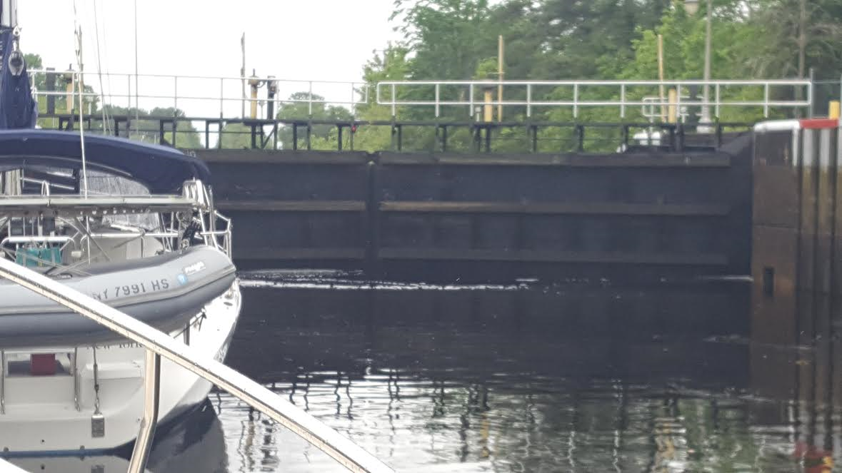
Another new experience was going through our first lock on the loop.  There will be many more to come, including one tomorrow.  It is very cool.  The lock master lines everyone up on both sides of the lock.  He helps you to wrap a line from the bow and one from the stern to bollards that are on the sides about 10 feet up.  Then he closes the back of the lock and opens the front some to let the water rise.  All the boats rise along the sides and finally, he opens the front of the lock the whole way and everyone leaves the lock on their merry way.
View from inside the South Mills Lock

Another new experience came when we got to the Dismal Swamp Canal Visitor Center.  There is a nice dock but only enough space for 3-4 boats.  So extra boats raft up to your boat so that everyone has a place for the night.  We are on the dock and rafting with the folks from Knot Too Big.

The Dismal Swamp State Park is just a brief walk over a pontoon bridge.  It provided lots of history and information about the flora and fauna of the swamp.  Walking over the bridge it was neat to look at our boats.   Just over the bridge, I saw deer enjoying their day.  There is a boardwalk over the swamp.  While it had tons of mosquitos, it also had these beautiful flowers from the tulip trees.  There were birds and butterflies too numerous to count.

Tomorrow, we continue north and will cross into Virginia.

Lat 36 degrees 30.40 minutes North
Long 76 degrees 21.36 minutes West


Monday, May 2, 2016

5/2 Elizabeth City


Ducks in the Harbor planning their course
Yesterday, just as we were pulling into the Elizabeth City Harbor, the Coast Guard issued a securite warning that the Elizabeth City Bridge just north of the city docks was stuck in the down position.  The Hydrophilic needs close to 20 feet for us to go under a bridge and the clearance was only 4 feet in the down position, so we were not passing that bridge.

The Elizabeth City Welcome Center opened and gave us information to take our own walking tour of the area.  John and I walked the area.  There were many instances of fine and unusual architecture.  This one in right on the corner of the waterfront and it is for sale.  The Colonial Oil Filling Station with the original blue tile roof was built in 1931 for the Pure Oil Company and was first known as The Auto Fountain.
Colonial Oil Filling Station

It was a warm day in the mid 80's and very humid, even with a good breeze off the harbor.  After lunch John rested and I decided to walk to the Organic Grocery.  When crossing the street, I missed the curb and landed splayed out on the sidewalk.  My pride was hurt and I left a good deal of my skin on the sidewalk.  I was amazed that two cars stopped to make sure I was OK.  It was so kind of them.  When I got to the grocery and asked for some water for my tissue to clean up my leg, the employees gave me alcohol wipes to clean my leg and band aids.  The world really does have good people in it.

The Visitors Center had a wine and cheese reception at 5 pm for all the boaters on the docks.  Each woman was given one of the roses from the rose bushes.  There were interesting people here.  One sailboat had infantry soldiers from England.  They have been doing different legs of a journey that will take the boat back to England.  There are many loopers some who started in Michigan, Florida, etc.  We met one couple who are Gold loopers.  That means they have already completed the loop once.

Everyone watched the bridge maintenance crew all day.  At 5:30, they were able to open one half of the bridge and will be operating on a normal schedule tomorrow.  The forecast is for rain and I hope it will not be too bad.  If we do take off tomorrow, we will be going up the Dismal Swamp route.  The Dismal Swamp Canal and lands were once owned by George Washington.  I hope to learn more about the history so I can share it with my grandchildren when they read this blog.  Also there are two locks to go through. 

Lat 36 degrees 17.90 minutes North
Long 76 degrees 13.11 minutes West


Sunday, May 1, 2016

5/1 Elizabeth City

Crab pots to the left of me, crab pots to the right; here we are dodging crab pots again.

We crossed Albemarle Sound today.  The Sound is known for being choppy but we had a mild, pleasant crossing.  But the entire sound is populated with random crab pots, 14 miles of random crab pots.  Then we headed up the Pasquotank River to Elizabeth City, NC.  Elizabeth City is known for their roses and free docks.  The docks are back in to a very tiny finger slip (more like a fingernail slip) and although we were glad another looper caught our lines, we paid it forward and caught lines for others.  Each slip here is in honor of someone and we are in the Clark Slip.  Elizabeth City is where the Wright Bros. came to take a boat over to Kill Devil Hills. 
Weathervane on the Visitors Center

View of the Roses from the couch on the Hydrophilic

The Hydrophilic in the Clark Slip

Lat 36 degrees 17.91 minutes North
Long 76 degrees 13.11 minutes West